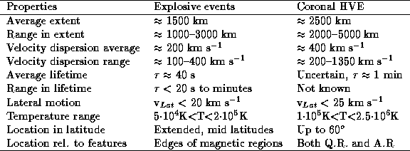
The observing sequences are based on the known properties of explosive and high velocity events by HRTS and SO82A/Skylab, respectively listed in the table.
Explosive events occur frequently in the lower transition region and typically one event are seen in the SUMER slit (l=120'') every few minutes. We will therefore co-point CDS and SUMER to the best possible accuracy, i.e. 10-15''. SUMER will then run its POP08 while CDS performs a small raster, 20'' wide. The initial pointing will be selected and is most likely to be located at mid--latitude for initial runs of the JOP.
In order to test the SUMER and CDS co-pointing we may run a 4'
 4' raster of the region surrounding the target area. For
mapping CDS uses the sequence TEST6-1 and a similar survey is run by
by SUMER. From these images the relative pointing of the two
instruments may be estimated and adjusted to the required accuracy.
Results from this initial phase, the mapping phase, may be used to:
4' raster of the region surrounding the target area. For
mapping CDS uses the sequence TEST6-1 and a similar survey is run by
by SUMER. From these images the relative pointing of the two
instruments may be estimated and adjusted to the required accuracy.
Results from this initial phase, the mapping phase, may be used to:
Regarding the last point it should be noted that explosive events tend
to be most frequent in the supergranulation network or regions with
activity. It is therefore advantageous to have high resolution MDI
and EIT images of the target region as close as possible to the start
of the JOP as well as ground based Ca II and H .
.
After the mapping the search and study phase will commence, either
right away or after a pause to check and adjust the co-pointing from
the mapping. The SUMER POP08 will be performed in one of two lines, O
IV 790 A or Si IV 1393 A emitted at 1.7 10
10 K and
0.7
K and
0.7 10
10 K, respectively. CDS observes lines formed throughout
the transition region and corona. When SUMER discovers an event the
used part of the slit is shortened and centred on the event, and a
small raster is initiated. This ensures spatial mapping of the
explosive event feature while maintaining reasonable information on
the time history of the event.
K, respectively. CDS observes lines formed throughout
the transition region and corona. When SUMER discovers an event the
used part of the slit is shortened and centred on the event, and a
small raster is initiated. This ensures spatial mapping of the
explosive event feature while maintaining reasonable information on
the time history of the event.